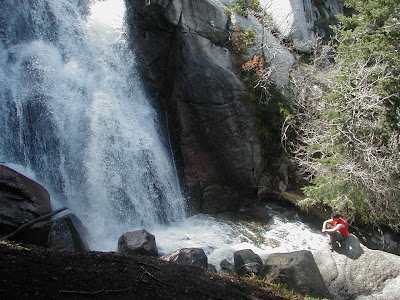
3.26.2010

Across from Log Haven, Millcreek Canyon


Across from Log Haven, Millcreek Canyon

• 4 miles up Millcreek Canyon
• From Interstate 15, take Interstate 80 East to Interstate 215 South. Take exit for 39th South, turn left at the end of the ramp, left onto Wasatch Boulevard, then turn right at 3800 South traffic light
• On the right hand side as you are going up the canyon


Join Sheryl's Hiking Group today or Schedule your OWN customized Hiking Outing with Sheryl!
Website: liveandthrive.com Email: sheryl@liveandthrive.com

Stairs Gulch, Big Cottonwood Canyon


Stairs Gulch, Big Cottonwood Canyon

• Stairs Gulch is a challenging and infrequently used route to the summit of Broads Fork Twin Peaks. This is a steep route, climbing over 5,500 vertical feet in less than 3 miles.
• This route description assumes a late spring / early summer ascent, when the gulch will contain extended consolidated snow fields. This is the preferred time to attempt this route. Expect considerably differing conditions for later summer or autumn attempts, after all snow has melted.
• Stairs Gulch is notorious for monstrous avalanches during winter and early spring
• This route begins across the road from the Storm Mountain Picnic Area in Big Cottonwood Canyon. Take the 6200 South exit (exit #6) off I-215 and follow highway 190 south-east approximately 2 miles to the intersection with Big Cottonwood Canyon road (State Highway 190).


Join Sheryl's Hiking Group today or Schedule your OWN customized Hiking Outing with Sheryl!
Website: liveandthrive.com Email: sheryl@liveandthrive.com

Bonneville Shoreline Trail, Draper section


Bonneville Shoreline Trail, Draper section

• Near the Orson Smith trailhead area
• Seasonal waterfall with the spring runoff


Join Sheryl's Hiking Group today or Schedule your OWN customized Hiking Outing with Sheryl!
Website: liveandthrive.com Email: sheryl@liveandthrive.com

Ghost Falls, near Draper, Utah


Ghost Falls, near Draper, Utah

• Round trip miles: 6.2 miles
• Hiking time: 4 to 5 hours
• Elevation gain: 920 feet
• Difficulty: Moderate
• Dogs allowed: Yes, on leash
• Trailhead Restrooms: Yes
• Mountain biking: Yes
• From the parking area, start on the Upper Corner Canyon Road. The road climbs gently on the shadeless hillside as it heads south for the canyon
• At 1.2 miles in, you come to the junction for the Bonneville Shoreline Trail. Go right and leave the road for the trail. As you approach the canyon and before the trail drops to the canyon floor, take the second trail on the left for Ghost Falls
• Trail isn’t posted. The trail drop into the trees and crosses the creek
• After crossing, stay to the right, where the trail loops back around, heads uphill and follows near the creek on the southside. Watch for a trail split on the left that crosses the creek and take it. About 2.5 miles in you come to Ghost Falls
• Just past the falls is a trail split on the left. Take this trail to the overlook. Enjoy the canyon view at the overlook, backtrack down and go left at the junction. You are now on the Ghost Falls South Trail
• Directions: From Interstate 15, take the 12300 South exit. Head east on 12300 South to 1300 East. At 1300 East go right (south) to the roundabout. Take the last spur on the roundabout for Pioneer Road. At 2000 East go right (south). Park at the Orson Smith Trail Head Park


Join Sheryl's Hiking Group today or Schedule your OWN customized Hiking Outing with Sheryl!
Website: liveandthrive.com Email: sheryl@liveandthrive.com

Ferguson Canyon, near Big Cottonwood Canyon


Ferguson Canyon, near Big Cottonwood Canyon

• Distance Round Trip: 3.5 mi (Ridge Overlook), 
5.5 mi (Upper Meadow)
• Skill Level: Moderate, trail gets much steeper after the first 1/2 mile
• Duration: 2 - 3 hours
• Dogs are allowed
• After about 1.5 miles, path becomes poorly maintained and, because of dogs and hikers veering off of it, it’s not well-defined
• From the 6200 South exit (exit #6) off I-215 follow highway 190 south-east approximately 2 miles to the intersection with Big Cottonwood Canyon road. Continue straight (south) through this stoplight for approximately 1/3 mile and turn left (east), then make an immediate right onto Prospector Drive at the T-junction. Approximately 1/4 mile beyond the T-junction turn left onto Timberline Drive. Proceed several hundred feet to the dirt road which leaves the main road on the right, which is where the trail begins. This is located in a residential area, so show consideration for the property owners.
• Ferguson Canyon is a little-known retreat near residential areas where you can find yourself in a secluded wilderness setting just minutes from the city. Ideal for a peaceful getaway, a walk with the dog, or a chance to see fall colors.


Join Sheryl's Hiking Group today or Schedule your OWN customized Hiking Outing with Sheryl!
Website: liveandthrive.com Email: sheryl@liveandthrive.com

Farmington Canyon Waterfall


Farmington Creek Canyon

· Wasatch Mountains
· About 45 min drive north of SLC
· Partially shaded.
· Not much traffic. Nice quiet trail
· Moderate Hike
· 2.6 RT to the Waterfall
· Dogs on a leash are allowed
· 2 – 3 hours
· Trail comes within 50 ft. of a broad waterfall
· Watch for wildlife
· Watch for two old cars that plunged over the cliff nearly 50 years ago.
· Beautiful, green, thick foliage

Join Sheryl's Hiking Group today or Schedule your OWN customized Hiking Outing with Sheryl!
Website: liveandthrive.com Email: sheryl@liveandthrive.com

Donut Falls, Big Cottonwood Canyon


Donut Falls, Big Cottonwood Canyon

• Trail has a slight elevation gain but is great for hikers of all ages
• Distance to Doughnut Falls- ¾ mile
• Skill Level: Easy
• The name "Doughnut Falls" is derived from the round shaped hole in the roof of the cave that a small stream tumbles through
• A few minor challenges keep the trail interesting, including a short drop-off to the creek bottom below the falls
• The turn off to the falls is located approx 9 miles up Big Cottonwood Canyon.
• Take a right and drive past the Jordan Pines Picnic Area and some private property to the trailhead parking lot. The parking lot offers parking for several cars, however due to the popularity of this hike this lot fills up fast especially on the weekends
• Trail starts to south of the parking lot by the restrooms


Join Sheryl's Hiking Group today or Schedule your OWN customized Hiking Outing with Sheryl!
Website: liveandthrive.com Email: sheryl@liveandthrive.com

Corner Canyon, Draper area


• Called "Corner Canyon" because it's the Southeast Corner of the Salt Lake Valley
• Draper Area, near the LDS Draper Temple
• Wide assortment of easy trails
• Popular Mountain Biking and Hiking area
• Dogs allowed
• Discover a variety of smaller unexpected waterfalls
• Kid and Family Friendly

Join Sheryl's Hiking Group today or Schedule your OWN customized Hiking Outing with Sheryl!
Website: liveandthrive.com Email: sheryl@liveandthrive.com

City Creek Canyon


City Creek Canyon

• Location: Trail begins at the end of Memory grove and goes up to Rotary Park
• Length: 12 mile roundtrip
• Difficulty: Beginner, Easy for children
• Time To Allow: 2.5 hrs
• Less than one mile (1.6 km) from the Utah State Capitol and downtown Salt Lake City, the canyon around City Creek is virtually unimproved
• Dogs are allowed in the canyon on-leash below the water treatment plant and watershed area
• Directions: From 11th Avenue and B Street, turn north onto East Bonneville Blvd. Take this one-way road and park near the City Creek Canyon road turn off. There is limited parking and the trail is clearly marked


Join Sheryl's Hiking Group today or Schedule your OWN customized Hiking Outing with Sheryl!
Website: liveandthrive.com Email: sheryl@liveandthrive.com

Church Fork Waterfall


Church Fork
Wasatch Mountains
Millcreek Canyon
Mouth: 3800 So. Wasatch Blvd.
$3 fee to get out of canyon
Less traffic because of no ski resort
Dog Friendly
Kid and Friendly Waterfall
Picnic area w/ campfires
View up close
¼ mile hike
3 miles up Canyon
Play in the water
April – October

Join Sheryl's Hiking Group today or Schedule your OWN customized Hiking Outing with Sheryl!
Website: liveandthrive.com Email: sheryl@liveandthrive.com

Calf Creek Falls, Highway 12, Southern Utah


Lower Calf Creek Falls

· 4.5 hours from SLC (268 miles from SLC)
· 130 ft. waterfall
· Cool water to swim in
· Surrounded by Sandstone cliffs
· 6 mile RT hike
· Walking in Sand
· Bring Extra clothes for swimming
· Southern Utah area
· Between the towns of Escalante and Boulder
· Dogs not recommended due to hot sand
· Amazingly BEAUTIFUL!!!
· Moderate Hike
· Start early. This hike gets hot by 11 am
· Indian Petroglyphs
· 3 – 4 hour RT
· Slick rock shallow creek
· Lots of Green Foliage all the way to the Waterfall
· Hidden treasure out in the middle of nowhere
· Directions: Travel through Dixie National Forest and plenty of other breath taking scenery to get there!
Head South on I-15. At Scipio, turn left on US 50, At the Aurora Sign, turn Right on UT 260, Follow the signs to Sigurd, Turn Right at UT 24, Stay on UT 24 until you arrive at Torrey. Turn Right on Scenic All American Highway 12. 48 miles to the entrance of Calf Creek Recreation Area (between milepost 75 & 76).
Follow the paved side road (approx. 200 yards) to the day-use parking area and trailhead

NOTE: The trailhead contains an information kiosk and a modern restroom. A small fee, approx. $2, is required to park in the day use area and is payable at the information kiosk.
Camping is available near the trailhead. The BLM maintained campground contains 13 sites available on a first come first served bases. Camping cost: Approx. $7.00/night.

Join Sheryl's Hiking Group today or Schedule your OWN customized Hiking Outing with Sheryl!
Website: liveandthrive.com Email: sheryl@liveandthrive.com

Lisa Falls, Little Cottonwood Canyon


Lisa Falls

· Wasatch Mountains
· Little Cottonwood Canyon
· This canyon has more traffic due to two ski resorts
· No dogs allowed
· The Trailhead is unmarked
· Kid and Family Friendly
· Easy boulder scrambling
· Kids love this trail because of the rocks
· 5 – 10 minute hike, one way
· 1/10 mile in length, one way
· Short, semi-steep trail
· Fun to play in water – depending on the runoff
· View up close – depending on the runoff
· Boulder hopping
· Popular rock climbing/repelling area
· Waterfall comes off a sheer granite slab
· Directions: The trailhead is located between mileposts 6 & 7. Look for a small parking area on the north side.
· Lisa Falls is 2.5 miles down the canyon from White Pine Trailhead, located on the NORTH side of the road.

Join Sheryl's Hiking Group today or Schedule your OWN customized Hiking Outing with Sheryl!
Website: liveandthrive.com Email: sheryl@liveandthrive.com

Bells Falls, Bells Canyon, near Little Cottonwood Canyon


Bells Canyon
Wasatch Mountains
Just SOUTH of Little Cottonwood Canyon
Trailhead 1/8 mile EAST of 9400 So. & Wasatch Blvd.
No fees
No much traffic
No dogs
Intermediate Hikers
RT Hike:
3 – 4 hours
Half of the hike is Boulder Stair Climbing
Wide Waterfall
Amazing giant Granite Slabs all along the trail
Pass a reservoir
Wildlife

Join Sheryl's Hiking Group today or Schedule your OWN customized Hiking Outing with Sheryl!
Website: liveandthrive.com Email: sheryl@liveandthrive.com

Hidden Falls, Big Cottonwood Canyon


Hidden Falls, Big Cottonwood Canyon

• Hidden Falls is a nice hike for younger children and the elderly
• Elevation gain of 40 feet
• Total distance of .3 miles
• After crossing the highway from the parking lot, take the lower left trail into the shade of the trees, avoiding the second set of stairs on the right, (these lead to the Mill B North Fork Overlook trail). From here, a short gentle climb is all that is required to reach the mist of the falls, where the tranquil sound of the falling water and the hidden location gives one the sense of being in another world, far from the road.
• This trail is unpaved, and although it only takes a few minutes to cover, it provides terrain interesting enough to make it challenging for youngsters. Please take caution when approaching the falls; the rocks may be slippery from spray.
• To reach the trailhead, drive 4.4 miles up Big Cottonwood Canyon on Utah 190. Park in the small lot located on the right (southeast) side of the road in the second, upper curve of the "S-Turn." The trail is above the lot on the opposite (north) side of the road. Additional parking can be found at the lower parking area, where a small road branches right (southeast) from the lower curve of the "S-Turn."


Join Sheryl's Hiking Group today or Schedule your OWN customized Hiking Outing with Sheryl!
Website: liveandthrive.com Email: sheryl@liveandthrive.com